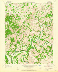
1954 Map of Lucas
USGS Topo · Published 1964About this map
Skaggs Creek and the Barren River dominate this mid-century portrait of the Barren and Allen County line, captured shortly before the landscape was altered by massive water management projects. The map reveals a densely settled rural community defined by its proximity to these winding watercourses, particularly at the Narrows, where the river loops sharply through the limestone terrain.
Find a feature on this map
27 named features on this map. Tap any name to fly to it.
Don’t see what you’re looking for? This feature index may not catch every label — zoom into the map to look around manually.
Map Details
Editions of this 1954 Lucas Map
This is the sole edition of this map. No revisions or reprints were ever made.
Other maps of this area

1922 · Mammoth Cave
USGS Topo · 1:62,500

1923 · Mammoth Cave
USGS Topo · 1:62,500

1926 · Scottsville
USGS Topo · 1:62,500

1935 · Horse Cave
USGS Topo · 1:48,000

1938 · Horse Cave
USGS Topo · 1:62,500

1953 · Tracy
USGS Topo · 1:24,000

1953 · Glasgow South
USGS Topo · 1:24,000

1954 · Evansville
USGS Topo · 1:250,000

1954 · Austin
USGS Topo · 1:24,000
1954 · Park City
USGS Topo · 1:24,000