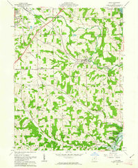
1961 Map of Lucas
USGS Topo · Published 1963About this map
The Pennsylvania railroad corridor defines the mid-century valley landscape of southeastern Richland County, connecting the bustling outskirts of Mansfield with the village of Lucas. This 1961 survey captures a rural landscape undergoing hydraulic transformation, anchored by the Muskingum Watershed Conservancy District and the rising waters of the Charles Mill Reservoir. In the southern reaches, the Gas Field near Newville points to the area's subterranean resources, while local heritage is preserved in sites like Culler Mill and Odd Fellows Cem. The map illustrates a transitional period where established settlements like Little Washington and Hastings remain vital nodes even as recreational features like Hidden Hollow Camp begin to appear along the rugged drainages of the Rocky Fork and Switzer Creek.
Find a feature on this map
61 named features on this map. Tap any name to fly to it.
Don’t see what you’re looking for? This feature index may not catch every label — zoom into the map to look around manually.
Map Details
Editions of this 1961 Lucas Map
3 editions found
Other maps of this area

1908 · Ashland
USGS Topo · 1:62,500

1912 · Perrysville
USGS Topo · 1:62,500

1915 · Crestline
USGS Topo · 1:62,500

1915 · Perrysville
USGS Topo · 1:62,500

1915 · Shauck
USGS Topo · 1:62,500

1943 · Shauck
USGS Topo · 1:62,500

1943 · Crestline
USGS Topo · 1:62,500

1944 · Perrysville
USGS Topo · 1:62,500

1950 · Marion
USGS Topo · 1:250,000

1960 · Pavonia
USGS Topo · 1:24,000