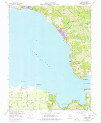
1958 Map of Lucerne
USGS Topo · Published 1978About this map
Clear Lake dominates the center of this landscape, its shoreline dotted with recreational settlements and agricultural lands during the mid-twentieth century. Along the northern coast, the community of Lucerne sits at the foot of the Mendocino National Forest, while the village of Nice marks the approach to Laurel Beach. To the south, the flat expanse of Big Valley is home to the rural center of Finley and extensive irrigation infrastructure indicated by numerous wells. The 1975 revisions highlight the growth of residential areas around Lakeside Park and the peninsula of Soda Bay. This period reflects the dual character of the region as both a productive farming valley and a developing vacation destination, centered on the protected waters of Dorn Bay and the wooded trails of Clear Lake State Park.
Find a feature on this map
42 named features on this map. Tap any name to fly to it.
Don’t see what you’re looking for? This feature index may not catch every label — zoom into the map to look around manually.
Map Details
Editions of this 1958 Lucerne Map
4 editions found
Other maps of this area

1921 · Kelseyville
USGS Topo · 1:62,500

1924 · Bartlett Springs
USGS Topo · 1:62,500

1938 · Lakeport
USGS Topo · 1:62,500

1942 · Bartlett Springs
USGS Topo · 1:62,500

1943 · Kelseyville
USGS Topo · 1:62,500

1944 · Bartlett Springs
USGS Topo · 1:62,500

1945 · Lower Lake
USGS Topo · 1:62,500

1947 · Santa Rosa
USGS Topo · 1:250,000

1949 · Santa Rosa
USGS Topo · 1:250,000

1951 · Lakeport
USGS Topo · 1:62,500