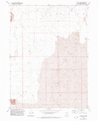
1991 Map of Lucin 4 NW
USGS Topo · Published 1991About this map
Silver Island Mts and the landform known as Crater Island anchor the southwestern corner of this desert landscape in Box Elder County. The terrain is defined by the expansive presence of Mud, a flat playa environment that stretches across the eastern half of the sheet. This 1991 edition captures the hydrology of the Great Salt Lake Desert, where intermittent water sources and industrial exploration markers punctuate the arid basin. Water features are concentrated in the north, including Flowing Wells and several named Springs. These natural outflows are contrasted by numerous Drill Hole sites, indicating geological or resource exploration during the late 20th century. In the northwest, the Little Pigeon Mts rise above the basin floor, while Miry Wash cuts through the desert floor to the south, tracing a seasonal drainage path toward the mudflats.
Find a feature on this map
10 named features on this map. Tap any name to fly to it.
Don’t see what you’re looking for? This feature index may not catch every label — zoom into the map to look around manually.
Map Details
Editions of this 1991 Lucin 4 NW Map
2 editions found
Other maps of this area

1954 · Brigham City
USGS Topo · 1:250,000

1958 · Brigham City
USGS Topo · 1:250,000

1962 · Brigham City
USGS Topo · 1:250,000

1967 · Pigeon Mountain
USGS Topo · 1:24,000

1967 · Lemay Island
USGS Topo · 1:24,000

1970 · Crater Island
USGS Topo · 1:24,000

1983 · Jackson
USGS Topo · 1:24,000
1983 · Lucin 4 SW
USGS Topo · 1:24,000

1983 · Bovine SE
USGS Topo · 1:24,000

1983 · Lucin 4 NE
USGS Topo · 1:24,000