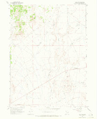
1967 Map of Lucin NW
USGS Topo · Published 1971About this map
The Old Emigrant (Jeep) Trail snakes across the high desert floor of Box Elder County, marking a historic corridor of western movement through this remote corner of Utah. Surveyed in the late 1960s, the landscape is defined by the ephemeral Grouse Creek and a network of Jeep Trails that connect scattered mining operations. Evidence of industrial and migratory history is visible in several Prospects, a Mine, and the small crossroads at Grouse Creek Junction. The southern edge of the sheet is anchored by the infrastructure of the Southern Pacific railroad, illustrating the region's continued role as a vital transportation artery. This map provides a detailed view of the terrain before modern developments, highlighting the intersection of 19th-century pioneer routes with 20th-century resource extraction and rail transport.
Find a feature on this map
10 named features on this map. Tap any name to fly to it.
Don’t see what you’re looking for? This feature index may not catch every label — zoom into the map to look around manually.
Map Details
Editions of this 1967 Lucin NW Map
3 editions found
Other maps of this area

1954 · Brigham City
USGS Topo · 1:250,000

1955 · Wells
USGS Topo · 1:250,000

1958 · Wells
USGS Topo · 1:250,000

1958 · Brigham City
USGS Topo · 1:250,000

1961 · Wells
USGS Topo · 1:250,000

1961 · Dairy Valley
USGS Topo · 1:62,500

1962 · Brigham City
USGS Topo · 1:250,000

1967 · Jackson Spring
USGS Topo · 1:24,000

1967 · Pigeon Mountain
USGS Topo · 1:24,000

1967 · Lucin
USGS Topo · 1:24,000