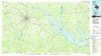
1986 Map of Lufkin
USGS Topo · Published 1986About this map
Sam Rayburn Reservoir dominates the eastern half of this East Texas landscape, its sprawling shoreline reaching into the Angelina National Forest and Sabine National Forest. The region’s deep connection to the timber and rail industries is evident in the dense network of lines, including the Angelina & Neches River and the Texas South-Eastern railroads. In Lufkin, the convergence of major transit routes like U.S. 59 and the Southern Pacific tracks highlights its role as a regional hub, while smaller surrounding settlements like Keltys, Herty, and Diboll maintain their own distinct footprints.
Find a feature on this map
283 named features on this map. Tap any name to fly to it.
Don’t see what you’re looking for? This feature index may not catch every label — zoom into the map to look around manually.
Map Details
Editions of this 1986 Lufkin Map
This is the sole edition of this map. No revisions or reprints were ever made.
Other maps of this area

1927 · Lufkin 4-c
USGS Topo · 1:24,000

1928 · Zavalla 3-c
USGS Topo · 1:24,000

1928 · Lufkin 4-d
USGS Topo · 1:24,000

1931 · Zavalla
USGS Topo · 1:62,500

1932 · Manning
USGS Topo · 1:62,500

1944 · Patroon
USGS Topo · 1:62,500

1946 · Alto
USGS Topo · 1:62,500

1949 · Lufkin
USGS Topo · 1:62,500

1949 · Platt
USGS Topo · 1:24,000

1949 · Clawson
USGS Topo · 1:24,000