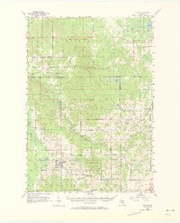
1957 Map of Luther
USGS Topo · Published 1973About this map
Luther serves as a primary hub for this mid-century survey of the Michigan north woods, situated where the Manistee River and Pine River watersheds converge. The landscape is defined by the vast tracts of the Manistee National Forest and Pere Marquette State Forest, yet it retains many markers of earlier rural settlement. Small community centers like Hoxeyville, Bristol, and Raymond Corners anchor the township divisions. For those tracing local history, the map preserves the locations of numerous country schools and churches, including the Taylor Sch and Clay Hill Ch. The presence of established burial grounds such as Nixon Sch Cem and Cherry Grove Cem provides specific data points for genealogists researching the families who worked these forest lands and small farms during the 1950s.
Find a feature on this map
49 named features on this map. Tap any name to fly to it.
Don’t see what you’re looking for? This feature index may not catch every label — zoom into the map to look around manually.
Map Details
Editions of this 1957 Luther Map
4 editions found

Other maps of this area

1931 · Chase NE
USGS Topo · 1:31,680

1931 · Baldwin NE
USGS Topo · 1:31,680

1932 · Chase NW
USGS Topo · 1:31,680

1933 · Peacock SE
USGS Topo · 1:31,680

1933 · Luther SE
USGS Topo · 1:31,680

1933 · Peacock NE
USGS Topo · 1:31,680

1933 · Luther SW
USGS Topo · 1:31,680

1933 · Luther NW
USGS Topo · 1:31,680

1954 · Traverse City
USGS Topo · 1:250,000

1954 · Midland
USGS Topo · 1:250,000