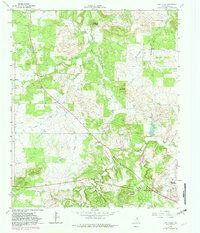
1964 Map of Lynn Creek
USGS Topo · Published 1982About this map
Squaw Mountain and Indian Hills define the varied topography of this Jack County landscape, where the rugged terrain is carved by the drainages of Cameron Creek and Lynn Creek. The map documents a mid-century period of resource extraction and community infrastructure, characterized by several Oil Fields and a Gaging Sta along the creek beds. Local history is anchored by the Lynn Creek Chapel and the Roberts Branch Cem, which serve as vital landmarks for genealogists tracing early families in the area. The presence of a Pipeline and a Gravel Pit alongside the primary road network indicates the industrial activity that shaped the region's economy. The survey also captures natural landmarks such as Round Mountain and the convergence of numerous branches, including Roper Branch and Henderson Creek.
Find a feature on this map
19 named features on this map. Tap any name to fly to it.
Don’t see what you’re looking for? This feature index may not catch every label — zoom into the map to look around manually.
Map Details
Editions of this 1964 Lynn Creek Map
2 editions found
Other maps of this area

1954 · Wichita Falls
USGS Topo · 1:250,000

1958 · Wichita Falls
USGS Topo · 1:250,000

1960 · Jacksboro
USGS Topo · 1:24,000

1962 · Antelope Creek NE
USGS Topo · 1:24,000

1964 · Senate
USGS Topo · 1:24,000

1964 · Johnson Lake
USGS Topo · 1:24,000

1964 · Darnell Branch
USGS Topo · 1:24,000

1964 · Bryson
USGS Topo · 1:24,000

1964 · Lynn Creek
USGS Topo · 1:24,000

1964 · Antelope
USGS Topo · 1:24,000