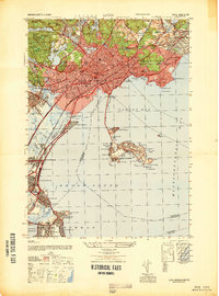
1947 Map of Lynn
USGS Topo · Published 1947About this map
Lynn and its coastal neighbors are captured here in the immediate post-war era, showing a landscape defined by dense urban grids and a rugged North Shore coastline. The city's industrial and civic infrastructure is prominent, from the City Farm and Isolation Hospital in the west to the expansive Pine Grove Cemetery. Along the waterfront, the Lynnway serves as a primary artery connecting the city to the General Edwards Bridge, while the State Bath House at Revere Beach marks the region's long-standing recreational appeal.
Find a feature on this map
105 named features on this map. Tap any name to fly to it.
Don’t see what you’re looking for? This feature index may not catch every label — zoom into the map to look around manually.
Map Details
Editions of this 1947 Lynn Map
This is the sole edition of this map. No revisions or reprints were ever made.
Other maps of this area

1886 · Lawrence
USGS Topo · 1:62,500

1888 · Lawrence
USGS Topo · 1:62,500

1888 · Salem
USGS Topo · 1:62,500

1892 · Boston Bay
USGS Topo · 1:62,500

1893 · Salem
USGS Topo · 1:62,500

1893 · Boston
USGS Topo · 1:62,500

1893 · Lawrence
USGS Topo · 1:62,500

1903 · Boston
USGS Topo · 1:62,500

1903 · Boston Bay
USGS Topo · 1:62,500

1917 · Salem
USGS Topo · 1:62,500