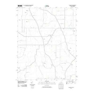
2010 Map of Lynnville
USGS Topo · Published 2010About this map
The agrarian landscape of the Kentucky-Tennessee borderlands is defined by a dense network of family and community burial grounds, illustrating the deep ancestral roots of this rural region. Waterways like West Fork Terrapin Creek and Bacon Creek drain the undulating land, while a grid of local roads reflects generations of farmstead division. Many of these routes carry the names of local families, such as Adams Rd and Judge Easley Rd. For genealogists and local historians, the sheer number of small cemeteries—including Kesterson Cemetery, Doublin Cemetery, and Boydsville Cemetery—suggests the locations of former pioneer homesteads and nineteenth-century settlements. The presence of Cuba School Rd points to earlier community centers in an area where the economy remains tied to the soil and the seasonal flow of Terrapin Creek.
Find a feature on this map
56 named features on this map. Tap any name to fly to it.
Don’t see what you’re looking for? This feature index may not catch every label — zoom into the map to look around manually.
Map Details
Editions of this 2010 Lynnville Map
This is the sole edition of this map. No revisions or reprints were ever made.
Other maps of this area

1936 · Farmington
USGS Topo · 1:24,000

1936 · Crossland
USGS Topo · 1:24,000

1936 · Lynn Grove
USGS Topo · 1:24,000

1936 · Kirksey
USGS Topo · 1:24,000

1950 · Cottage Grove
USGS Topo · 1:24,000

1951 · Kirksey
USGS Topo · 1:24,000

1951 · Farmington
USGS Topo · 1:24,000
1951 · Murray
USGS Topo · 1:62,500
1951 · Lynn Grove
USGS Topo · 1:24,000

1952 · Mayfield
USGS Topo · 1:24,000