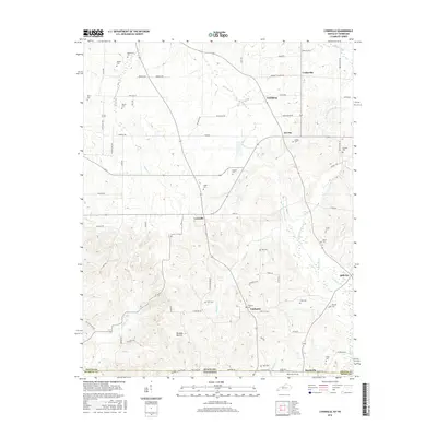
2016 Map of Lynnville
USGS Topo · Published 2016About this map
Lynnville and its surrounding rural hamlets sit at the border of Kentucky and Tennessee, where the landscape is defined by the headwaters and branches of the Obion Cr and Terrapin Cr. The 2016 geography reveals a high density of family and community burial grounds, such as Tibbs Cem, Kesterson Cem, and Andrus Cem, which serve as vital markers of the area's genealogical history. Small crossroads communities like Tri City, Vealsburg, and Fairbanks are connected by a network of winding roads like Cuba School Rd and Vealsburg Rd. In the south, the terrain levels into the Bumpas Bottom near the Graves Co Weakley Co line. This survey captures a modern look at a long-settled agricultural region where small watercourses like Bacon Cr and Caldwell Cr continue to shape the placement of farms and homesteads.
Find a feature on this map
83 named features on this map. Tap any name to fly to it.
Don’t see what you’re looking for? This feature index may not catch every label — zoom into the map to look around manually.
Map Details
Editions of this 2016 Lynnville Map
This is the sole edition of this map. No revisions or reprints were ever made.
Other maps of this area

1936 · Farmington
USGS Topo · 1:24,000

1936 · Crossland
USGS Topo · 1:24,000

1936 · Lynn Grove
USGS Topo · 1:24,000

1936 · Kirksey
USGS Topo · 1:24,000

1950 · Cottage Grove
USGS Topo · 1:24,000

1951 · Kirksey
USGS Topo · 1:24,000

1951 · Farmington
USGS Topo · 1:24,000
1951 · Murray
USGS Topo · 1:62,500
1951 · Lynn Grove
USGS Topo · 1:24,000

1952 · Mayfield
USGS Topo · 1:24,000