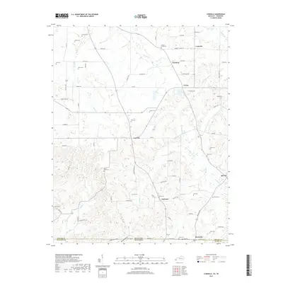
2019 Map of Lynnville
USGS Topo · Published 2019About this map
Lynnville serves as the central hub of this borderland region, where the flatlands of Bumpas Bottom meet the intricate creek networks of southern Graves County. This modern survey illustrates a landscape deeply rooted in family history, evidenced by the high density of small burial grounds such as Rhodes Chapel Cem, Andrus Cem, and Burnetts Chapel Cem that dot the countryside. The geography is defined by the northward flow of Mayfield Cr and the various forks of Terrapin Cr, which create the undulating drainage patterns characteristic of the Kentucky-Tennessee line. Small community centers like Tri City, Fairbanks, and Bell City are linked by a grid of rural routes including Beadles Rd and State Line Rd, maintaining a settlement pattern that has persisted for generations along the state boundary.
Find a feature on this map
80 named features on this map. Tap any name to fly to it.
Don’t see what you’re looking for? This feature index may not catch every label — zoom into the map to look around manually.
Map Details
Editions of this 2019 Lynnville Map
This is the sole edition of this map. No revisions or reprints were ever made.
Other maps of this area

1936 · Farmington
USGS Topo · 1:24,000

1936 · Crossland
USGS Topo · 1:24,000

1936 · Lynn Grove
USGS Topo · 1:24,000

1936 · Kirksey
USGS Topo · 1:24,000

1950 · Cottage Grove
USGS Topo · 1:24,000

1951 · Kirksey
USGS Topo · 1:24,000

1951 · Farmington
USGS Topo · 1:24,000
1951 · Murray
USGS Topo · 1:62,500
1951 · Lynn Grove
USGS Topo · 1:24,000

1952 · Mayfield
USGS Topo · 1:24,000