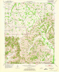
1952 Map of Lynnville
USGS Topo · Published 1973About this map
Lynnville serves as the central hub of this 1952 topographic study, situated just north of the border where Kentucky meets Tennessee. The landscape is characterized by a dense network of family-named cemeteries and rural institutions, reflecting the agricultural roots of Graves Co and Weakley Co. Significant landmarks such as Cuba High Sch and Burnett Chapel indicate the community focal points of the era, while the drainage patterns of Terrapin Creek and Bacon Creek define the local topography.
Find a feature on this map
34 named features on this map. Tap any name to fly to it.
Don’t see what you’re looking for? This feature index may not catch every label — zoom into the map to look around manually.
Map Details
Editions of this 1952 Lynnville Map
This is the sole edition of this map. No revisions or reprints were ever made.
Other maps of this area

1936 · Farmington
USGS Topo · 1:24,000

1936 · Crossland
USGS Topo · 1:24,000

1936 · Lynn Grove
USGS Topo · 1:24,000

1936 · Kirksey
USGS Topo · 1:24,000

1950 · Cottage Grove
USGS Topo · 1:24,000

1951 · Kirksey
USGS Topo · 1:24,000

1951 · Farmington
USGS Topo · 1:24,000
1951 · Murray
USGS Topo · 1:62,500
1951 · Lynn Grove
USGS Topo · 1:24,000

1952 · Mayfield
USGS Topo · 1:24,000