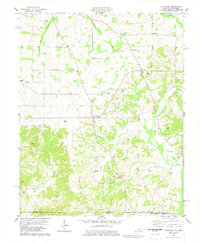
1978 Map of Lynnville
USGS Topo · Published 1978About this map
Lynnville serves as a central hub in this landscape of the Kentucky-Tennessee borderlands, where the terrain is defined by the headwaters of numerous creeks flowing toward the north and south. The map documents a dense network of family-named cemeteries and rural congregations, such as Burnetta Chapel and Rhodes Chapel, which underscore the deep genealogical roots of Graves Co and Weakley Co. The settlement pattern follows the drainage of Terrapin Creek and Bacon Creek, with small communities like Tri City and Bell City positioned along the early roadway routes.
Find a feature on this map
63 named features on this map. Tap any name to fly to it.
Don’t see what you’re looking for? This feature index may not catch every label — zoom into the map to look around manually.
Map Details
Editions of this 1978 Lynnville Map
This is the sole edition of this map. No revisions or reprints were ever made.
Other maps of this area

1936 · Farmington
USGS Topo · 1:24,000

1936 · Crossland
USGS Topo · 1:24,000

1936 · Lynn Grove
USGS Topo · 1:24,000

1936 · Kirksey
USGS Topo · 1:24,000

1950 · Cottage Grove
USGS Topo · 1:24,000

1951 · Kirksey
USGS Topo · 1:24,000

1951 · Farmington
USGS Topo · 1:24,000
1951 · Murray
USGS Topo · 1:62,500
1951 · Lynn Grove
USGS Topo · 1:24,000

1952 · Mayfield
USGS Topo · 1:24,000