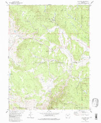
1980 Map of Lynx Pass
USGS Topo · Published 1986About this map
Routt National Forest dominates this mountain landscape, defined by a high-altitude network of drainage systems and isolated outposts. The prominent Lynx Pass serves as a geographic anchor near the Guard Sta and Lagunita Lake, while the topography is deeply etched by Deadman Gulch and Coberly Gulch. The arrangement of water resources, including Bulkley Reservoir and Hadley Reservoir, alongside numerous unnamed springs and a Gaging Sta on Horse Creek, indicates a landscape managed for both timber and water control.
Find a feature on this map
33 named features on this map. Tap any name to fly to it.
Don’t see what you’re looking for? This feature index may not catch every label — zoom into the map to look around manually.
Map Details
Editions of this 1980 Lynx Pass Map
4 editions found
Other maps of this area

1954 · Craig
USGS Topo · 1:250,000

1956 · Gore Pass
USGS Topo · 1:62,500

1957 · Craig
USGS Topo · 1:250,000

1957 · Leadville
USGS Topo · 1:250,000

1958 · Craig
USGS Topo · 1:250,000

1959 · Leadville
USGS Topo · 1:250,000

1960 · Leadville
USGS Topo · 1:250,000

1960 · Craig
USGS Topo · 1:250,000

1962 · Leadville
USGS Topo · 1:250,000

1962 · Craig
USGS Topo · 1:250,000