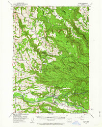
1951 Map of Lyons
USGS Topo · Published 1963About this map
Silver Creek Falls State Park dominates the central landscape of this 1951 survey, capturing a world-renowned natural area before the height of modern tourism expansion. The map details a dense concentration of cascades including Double Falls, Drake Falls, and South Falls, alongside facilities like the South Silver Creek Youth Camp. Beyond the park boundaries, the transition from the rugged timberlands of Wildcat Ridge and Abiqua Basin to the agricultural valley floor is evident. The North Santiam River corridor serves as the industrial and social spine of the region, where the Southern Pacific railroad connects the timber and farming communities of Mehama and Lyons. Local life is anchored by institutional landmarks such as the Santiarn Valley Grange and Mari-Linn Sch, while the presence of the Couch Mansion and Union Hill Cemetery provides vital clues for genealogists and local historians tracing early valley families.
Find a feature on this map
78 named features on this map. Tap any name to fly to it.
Don’t see what you’re looking for? This feature index may not catch every label — zoom into the map to look around manually.
Map Details
Editions of this 1951 Lyons Map
4 editions found

Other maps of this area

1916 · Estacada
USGS Topo · 1:125,000

1921 · Lebanon
USGS Topo · 1:62,500

1922 · Lebanon
USGS Topo · 1:48,000

1923 · Mount Angel
USGS Topo · 1:62,500

1924 · Lebanon
USGS Topo · 1:62,500

1925 · Stayton
USGS Topo · 1:62,500

1929 · Mill City
USGS Topo · 1:125,000

1939 · Molalla
USGS Topo · 1:62,500

1940 · Molalla
USGS Topo · 1:62,500

1940 · Lebanon
USGS Topo · 1:62,500