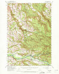
1951 Map of Lyons
USGS Topo · Published 1972About this map
The rugged canyonlands of the Cascade foothills define this 1951 landscape, centered on the expansive Silver Creek Falls State Park and its numerous cascades like Abiqua Falls and Drift Creek Falls. Settlement is concentrated along the river valleys and timbered ridges, with small communities like Mehama, Lyons, and the historic Silver Falls City serving as focal points for the local timber and agricultural economy. The map captures a transition period for rural education and social life, documenting sites such as Silvercrest Sch, Crooked Finger School, and the Silverton Hills Grange.
Find a feature on this map
66 named features on this map. Tap any name to fly to it.
Don’t see what you’re looking for? This feature index may not catch every label — zoom into the map to look around manually.
Map Details
Editions of this 1951 Lyons Map
4 editions found

Other maps of this area

1916 · Estacada
USGS Topo · 1:125,000

1921 · Lebanon
USGS Topo · 1:62,500

1922 · Lebanon
USGS Topo · 1:48,000

1923 · Mount Angel
USGS Topo · 1:62,500

1924 · Lebanon
USGS Topo · 1:62,500

1925 · Stayton
USGS Topo · 1:62,500

1929 · Mill City
USGS Topo · 1:125,000

1939 · Molalla
USGS Topo · 1:62,500

1940 · Molalla
USGS Topo · 1:62,500

1940 · Lebanon
USGS Topo · 1:62,500