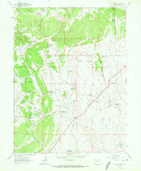
1962 Map of M F Mountain
USGS Topo · Published 1972About this map
M F Mountain and the surrounding high country of Moffat County are defined by a complex network of ranching infrastructure and seasonal water management in this 1962 survey. The landscape is dotted with named homesteads and specialized sites such as the Bar 24 Ranch, Railey Place, and Mobley Place, along with the Carver Cabin. These settlements represent the mid-century ranching life in the region, supported by an extensive system of reservoirs including the Wolf Creek Reservoir and a series of four Mancos Reservoirs designed to capture runoff in this arid terrain. Topography ranges from the drainage of Petes Post and The Sloughs to the prominent Baking Powder Ridge. The presence of several natural water sources like Three Springs and Yellow Cat Springs likely dictated the placement of early ranching hubs and livestock routes across Maverick Flats.
Find a feature on this map
36 named features on this map. Tap any name to fly to it.
Don’t see what you’re looking for? This feature index may not catch every label — zoom into the map to look around manually.
Map Details
Editions of this 1962 M F Mountain Map
3 editions found
Other maps of this area

1907 · Rangely
USGS Topo · 1:125,000

1907 · White River
USGS Topo · 1:125,000

1910 · White River
USGS Topo · 1:125,000

1910 · Rangely
USGS Topo · 1:125,000

1954 · Vernal
USGS Topo · 1:250,000

1958 · Vernal
USGS Topo · 1:250,000

1960 · Vernal
USGS Topo · 1:250,000

1960 · Elk Springs
USGS Topo · 1:62,500

1962 · Cactus Reservoir
USGS Topo · 1:24,000
1962 · Divide Creek
USGS Topo · 1:24,000