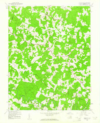
1943 Map of Mabelton
USGS Topo · Published 1961About this map
The South Anna River winds through the southern reaches of this Hanover County landscape, where rural life in the 1940s was anchored by crossroads settlements and country congregations. Mapping at this time shows a network of named junctions like Moudges Corner, Jones Corner, and Stanleys Corner, reflecting a localized social geography where small communities coalesced around key intersections and schoolhouses like Bethany Sch. The area near Montpelier serves as a central hub, while the Newfound River and Taylors Creek cut through the timbered terrain to the north.
Find a feature on this map
21 named features on this map. Tap any name to fly to it.
Don’t see what you’re looking for? This feature index may not catch every label — zoom into the map to look around manually.
Map Details
Editions of this 1943 Mabelton Map
2 editions found
Other maps of this area

1890 · Goochland
USGS Topo · 1:125,000

1892 · Goochland
USGS Topo · 1:125,000

1936 · Glen Allen
USGS Topo · 1:24,000

1941 · Glen Allen
USGS Topo · 1:31,680

1942 · Buckner
USGS Topo · 1:24,000

1942 · Beaverdam
USGS Topo · 1:24,000

1943 · Mabelton
USGS Topo · 1:31,680
1943 · Hanover Academy
USGS Topo · 1:31,680

1943 · Perkinsville
USGS Topo · 1:31,680
1943 · Buckner
USGS Topo · 1:31,680