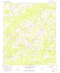
1960 Map of Macedonia
USGS Topo · Published 1978About this map
Macedonia and the surrounding Columbia County countryside are defined by a complex network of oil production and rural community life in this mid-century survey. The landscape is segmented into the Magnolia Oil Field, Dorgheat Macedonia Oil Field, and Buena Vista Oil Field, showing the intensive energy extraction of the era. Interspersed among the pipelines and gravel pits are the anchors of local genealogy, including Philadelphia, Hunt, and Harmony. A high density of rural spiritual centers like Pilgrims Rest Ch and New Zion Ch highlights the social fabric of these small settlements. Significant watercourses such as Big Creek and Hurricane Creek drain the terrain, while landmarks like Rocky Mound provide distinctive elevation markers in a region where industry and small-town Arkansas life were closely intertwined.
Find a feature on this map
33 named features on this map. Tap any name to fly to it.
Don’t see what you’re looking for? This feature index may not catch every label — zoom into the map to look around manually.
Map Details
Editions of this 1960 Macedonia Map
4 editions found
Other maps of this area

1953 · El Dorado
USGS Topo · 1:250,000

1957 · El Dorado
USGS Topo · 1:250,000

1958 · El Dorado
USGS Topo · 1:250,000

1960 · El Dorado
USGS Topo · 1:250,000

1960 · Bussey
USGS Topo · 1:24,000
1960 · Taylor
USGS Topo · 1:24,000

1960 · Walkerville
USGS Topo · 1:24,000

1960 · Macedonia
USGS Topo · 1:24,000

1966 · Calhoun
USGS Topo · 1:24,000

1968 · Buckner
USGS Topo · 1:24,000