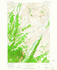
1956 Map of Mackay Ranch
USGS Topo · Published 1964About this map
Rosebud Creek carves a winding path through this rugged section of the Montana landscape, serving as a vital corridor for early 20th-century ranching operations. The map documents the intricate water management systems of the era, showcasing numerous irrigation channels such as the Phillips Ditch, Oakley-Parker Ditch, and the Peabody Canal that support the high-altitude pastures. These water features reveal the agricultural reliance on the creek as it flows between the Stillwater and Carbon county line.
Find a feature on this map
35 named features on this map. Tap any name to fly to it.
Don’t see what you’re looking for? This feature index may not catch every label — zoom into the map to look around manually.
Map Details
Editions of this 1956 Mackay Ranch Map
3 editions found
Other maps of this area

1898 · Granite Mountain District
USGS Topo · 1:125,000

1932 · Red Lodge No 2
USGS Topo · 1:48,000

1932 · Nye No 1
USGS Topo · 1:48,000

1954 · Billings
USGS Topo · 1:250,000
1956 · Emerald Lake
USGS Topo · 1:24,000
1956 · Fishtail
USGS Topo · 1:24,000

1956 · Roscoe
USGS Topo · 1:24,000

1956 · Alpine
USGS Topo · 1:62,500

1956 · Mackay Ranch
USGS Topo · 1:24,000

1956 · Roscoe NW
USGS Topo · 1:24,000