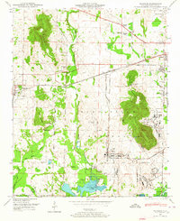
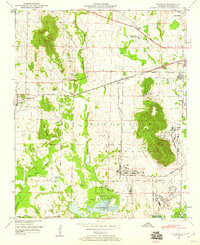
1948 Map of Madison
USGS Topo · Published 1964About this map
The Huntsville Arsenal Reservation dominates the landscape of Madison County in the late 1940s, marking a period of significant military expansion. This transition from rural farmland to a defense-focused geography is evident as the Huntsville Arsenal Boundary bisects the terrain, encompassing the Huntsville Arsenal Airfield and the Huntsville Arsenal Headquarters. To the north and west, the town of Madison remains a hub for the Southern Railway, which connects smaller settlements like Brandontown and Elko across the lowlands.
Find a feature on this map
50 named features on this map. Tap any name to fly to it.
Don’t see what you’re looking for? This feature index may not catch every label — zoom into the map to look around manually.
Map Details
Editions of this 1948 Madison Map
2 editions found
Other maps of this area

1888 · Huntsville
USGS Topo · 1:125,000

1892 · Huntsville
USGS Topo · 1:125,000

1936 · Jeff
USGS Topo · 1:24,000

1936 · Capshaw
USGS Topo · 1:24,000
1936 · Triana
USGS Topo · 1:24,000

1936 · Madison
USGS Topo · 1:24,000

1936 · Meridianville
USGS Topo · 1:24,000

1936 · Mason Ridge
USGS Topo · 1:24,000

1936 · Greenbrier
USGS Topo · 1:24,000

1936 · Farley
USGS Topo · 1:24,000