1950 Map of Madison
USGS Topo · Published 1950About this map
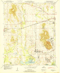
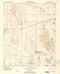
Huntsville Arsenal dominates the eastern half of this landscape, its expansive boundary lines encompassing critical infrastructure like the Huntsville Arsenal Airfield and Huntsville Arsenal Headquarters. To the west, the town of Madison sits along the Southern railroad line, serving as a settled counterpoint to the military reservation. The terrain is defined by prominent elevations including Rainbow Mountain, Ward Mountain, and Madkin Mountain, which overlook a network of rural roads and family landmarks. In the south, the landscape transitions into the Wheeler National Wildlife Refuge where the waters of the Wheeler Reservoir meet the mouths of Indian Creek and Barren Fk Cr. Genealogists will find numerous small burial grounds and community centers, from the Royal Cem and Farley Cem to local congregations at Payne Chapel and Spring Hill Ch.
Find a feature on this map
58 named features on this map. Tap any name to fly to it.
Don’t see what you’re looking for? This feature index may not catch every label — zoom into the map to look around manually.
Map Details
Editions of this 1950 Madison Map
2 editions found
Other maps of this area

1888 · Huntsville
USGS Topo · 1:125,000

1892 · Huntsville
USGS Topo · 1:125,000

1936 · Jeff
USGS Topo · 1:24,000

1936 · Capshaw
USGS Topo · 1:24,000
1936 · Triana
USGS Topo · 1:24,000

1936 · Madison
USGS Topo · 1:24,000

1936 · Meridianville
USGS Topo · 1:24,000

1936 · Mason Ridge
USGS Topo · 1:24,000

1936 · Greenbrier
USGS Topo · 1:24,000

1936 · Farley
USGS Topo · 1:24,000