1950 Map of Madison
USGS Topo · Published 1950About this map
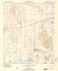
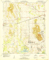
Madison stands as a rail-centered hub in the mid-century, bisected by the Southern railroad line while the surrounding countryside transitions toward heavy federal use. To the east and south, the Huntsville Arsenal Boundary demarcates a massive military footprint, containing the Huntsville Arsenal Headquarters and Huntsville Arsenal Airfield. This military landscape stands in sharp contrast to the established rural character found at Rainbow Mountain and the small communities like Westlawn and Brandontown.
Find a feature on this map
53 named features on this map. Tap any name to fly to it.
Don’t see what you’re looking for? This feature index may not catch every label — zoom into the map to look around manually.
Map Details
Editions of this 1950 Madison Map
2 editions found
Other maps of this area

1888 · Huntsville
USGS Topo · 1:125,000

1892 · Huntsville
USGS Topo · 1:125,000

1936 · Jeff
USGS Topo · 1:24,000

1936 · Capshaw
USGS Topo · 1:24,000
1936 · Triana
USGS Topo · 1:24,000

1936 · Madison
USGS Topo · 1:24,000

1936 · Meridianville
USGS Topo · 1:24,000

1936 · Mason Ridge
USGS Topo · 1:24,000

1936 · Greenbrier
USGS Topo · 1:24,000

1936 · Farley
USGS Topo · 1:24,000