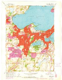
1959 Map of Madison West
USGS Topo · Published 1970About this map
The State Capitol stands as the central landmark of this mid-century survey, anchoring the isthmus between Lake Mendota and Lake Monona. This map captures a significant period of suburban expansion for Madison, with purple-tinted revision zones documenting the growth of Middleton and Shorewood Hills. Institutional and educational development is prominent, ranging from Edgewood College to the extensive University of Wisconsin Arboretum and the Academy of St Benedict on the northern shore.
Find a feature on this map
88 named features on this map. Tap any name to fly to it.
Don’t see what you’re looking for? This feature index may not catch every label — zoom into the map to look around manually.
Map Details
Editions of this 1959 Madison West Map
4 editions found
Other maps of this area

1889 · Evansville
USGS Topo · 1:62,500

1890 · Madison
USGS Topo · 1:62,500

1892 · Madison
USGS Topo · 1:62,500

1894 · Evansville
USGS Topo · 1:62,500

1904 · Madison
USGS Topo · 1:62,500

1906 · Evansville
USGS Topo · 1:62,500

1906 · Madison
USGS Topo · 1:62,500

1907 · Cross Plains
USGS Topo · 1:62,500

1909 · Cross Plains
USGS Topo · 1:62,500

1923 · New Glarus
USGS Topo · 1:62,500