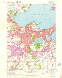
1959 Map of Madison West
USGS Topo · Published 1979About this map
Lake Mendota dominates the northern landscape of this mid-century survey, with its south shore serving as the intellectual and civic heart of the state. The sprawling University of Wisconsin campus and the iconic State Capitol form the urban core, while the extensive University of Wisconsin Arboretum preserves a significant natural buffer to the south near Lake Wingra. Purple revisions from the 1960s and 1970s illustrate a period of rapid suburbanization, particularly evident in the expanding residential tracts of Middleton and the southern reaches of Madison Twp. Transportation networks like the Chicago and North Western railroad connect these outlying areas to the city center. Local history is deeply etched into the landscape through long-established sites such as Forest Hill Cemetery and the Academy of St Benedict, alongside mid-century landmarks like the Mohs Seaplane Base.
Find a feature on this map
113 named features on this map. Tap any name to fly to it.
Don’t see what you’re looking for? This feature index may not catch every label — zoom into the map to look around manually.
Map Details
Editions of this 1959 Madison West Map
4 editions found
Other maps of this area

1889 · Evansville
USGS Topo · 1:62,500

1890 · Madison
USGS Topo · 1:62,500

1892 · Madison
USGS Topo · 1:62,500

1894 · Evansville
USGS Topo · 1:62,500

1904 · Madison
USGS Topo · 1:62,500

1906 · Evansville
USGS Topo · 1:62,500

1906 · Madison
USGS Topo · 1:62,500

1907 · Cross Plains
USGS Topo · 1:62,500

1909 · Cross Plains
USGS Topo · 1:62,500

1923 · New Glarus
USGS Topo · 1:62,500