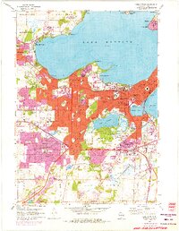
1959 Map of Madison West
USGS Topo · Published 1975About this map
Lake Mendota dominates this mid-century survey of the Wisconsin state capital, illustrating the city's complex relationship between its growing suburban tracts and the preserved natural landscape. The dense urban grid of Madison is shown pressing against institutional anchors like the Edgewood College and the sprawling University of Wisconsin Arboretum. This edition captures the post-war expansion into Middleton and the development of Shorewood Hills, where the residential landscape begins to negotiate the ridges and bluffs surrounding the water. Notable historical landmarks include the State Capitol and the Mohs Seaplane Base on the Mendota shoreline. Genealogists and local historians can trace legacy sites such as Forest Hill Cemetery and Calvary Cem, along with numerous neighborhood schools like Van Hise Sch and Dudgeon Sch that served the burgeoning mid-century population.
Find a feature on this map
89 named features on this map. Tap any name to fly to it.
Don’t see what you’re looking for? This feature index may not catch every label — zoom into the map to look around manually.
Map Details
Editions of this 1959 Madison West Map
4 editions found
Other maps of this area

1889 · Evansville
USGS Topo · 1:62,500

1890 · Madison
USGS Topo · 1:62,500

1892 · Madison
USGS Topo · 1:62,500

1894 · Evansville
USGS Topo · 1:62,500

1904 · Madison
USGS Topo · 1:62,500

1906 · Evansville
USGS Topo · 1:62,500

1906 · Madison
USGS Topo · 1:62,500

1907 · Cross Plains
USGS Topo · 1:62,500

1909 · Cross Plains
USGS Topo · 1:62,500

1923 · New Glarus
USGS Topo · 1:62,500