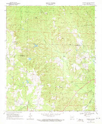
1969 Map of Magnolia NW
USGS Topo · Published 1971About this map
Glenville sits at the northern edge of this landscape, characterized by the winding tributaries of Smackover Creek and Crooked Creek. In the late 1960s, the region was defined by a balance between rural settlement and energy extraction, with the North Stephens Oil And Gas Field and Smart Oil And Gas Field marking the eastern border. These petroleum interests sit alongside long-established community landmarks such as Edwards Chapel and Davidson Ch.
Find a feature on this map
30 named features on this map. Tap any name to fly to it.
Don’t see what you’re looking for? This feature index may not catch every label — zoom into the map to look around manually.
Map Details
Editions of this 1969 Magnolia NW Map
2 editions found
Other maps of this area

1901 · Gurdon
USGS Topo · 1:125,000

1953 · El Dorado
USGS Topo · 1:250,000

1957 · El Dorado
USGS Topo · 1:250,000

1958 · El Dorado
USGS Topo · 1:250,000

1960 · El Dorado
USGS Topo · 1:250,000

1966 · Village
USGS Topo · 1:24,000

1968 · Lamartine
USGS Topo · 1:24,000

1968 · Waldo
USGS Topo · 1:24,000
1968 · Magnolia
USGS Topo · 1:24,000
1969 · Stephens
USGS Topo · 1:24,000