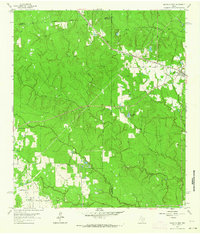
1962 Map of Magnolia West
USGS Topo · Published 1964About this map
The boundary lines of Grimes, Waller, and Montgomery counties converge in this 1962 landscape, where the Missouri Pacific railroad cuts a diagonal path toward the settlement of Magnolia. To the northwest, the small community of Fetzer sits near the tracks, while the surrounding terrain is defined by a dense network of waterways including Birch Creek, Mill Creek, and Walnut Creek. This survey captures the region before extensive modern suburbanization, showing a mix of agricultural clearings and wooded parcels.
Find a feature on this map
22 named features on this map. Tap any name to fly to it.
Don’t see what you’re looking for? This feature index may not catch every label — zoom into the map to look around manually.
Map Details
Editions of this 1962 Magnolia West Map
Other maps of this area

1916 · Rose Hill
USGS Topo · 1:24,000

1916 · Hockley
USGS Topo · 1:24,000

1920 · Hockley
USGS Topo · 1:31,680

1920 · Rose Hill
USGS Topo · 1:31,680

1920 · Waller
USGS Topo · 1:31,680

1954 · Beaumont
USGS Topo · 1:250,000

1957 · Beaumont
USGS Topo · 1:250,000

1960 · Waller
USGS Topo · 1:24,000

1960 · Waller NW
USGS Topo · 1:24,000

1961 · Stoneham
USGS Topo · 1:24,000