
1966 Map of Mahto NE
USGS Topo · Published 1967About this map
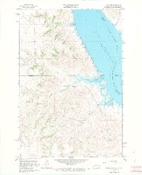
Oahe Reservoir dominates the eastern edge of this 1960s landscape, marking the flooded valley of the Missouri River along the state border between North Dakota and South Dakota. The sheet illustrates a complex intersection of administrative lines, where the Standing Rock Indian Reservation Boundary meets the borders of Sioux, Emmons, Campbell, and Corson counties. The terrain is defined by a network of drainage systems feeding the reservoir, including the winding paths of Fireheart Creek and Joe Bush Creek in the north, and Blackfoot Creek and Hunkpapa Cr to the south. State Line Bay provides a clear landmark where the rising waters of the reservoir crossed the state boundary. Significant elevation features such as Baldhead overlook the rugged breaks that lead down to the water’s edge, revealing the topography of the region before further modern development.
Find a feature on this map
14 named features on this map. Tap any name to fly to it.
Don’t see what you’re looking for? This feature index may not catch every label — zoom into the map to look around manually.
Map Details
Editions of this 1966 Mahto NE Map
2 editions found
Other maps of this area

1953 · McIntosh
USGS Topo · 1:250,000

1954 · Bismarck
USGS Topo · 1:250,000

1958 · Bismarck
USGS Topo · 1:250,000

1958 · McIntosh
USGS Topo · 1:250,000

1966 · Mahto
USGS Topo · 1:24,000

1966 · Kenel
USGS Topo · 1:24,000

1966 · Mahto NW
USGS Topo · 1:24,000

1966 · Kline Buttes
USGS Topo · 1:24,000

1966 · Pollock NW
USGS Topo · 1:24,000

1968 · Fort Yates SE
USGS Topo · 1:24,000