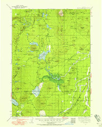
1930 Map of Maiden Peak
USGS Topo · Published 1930About this map
The High Cascades of central Oregon appear here as a landscape of volcanic buttes and high-altitude water systems during a period of active federal forest management. Forest Service presence is heavy throughout the Deschutes National Forest and Willamette National Forest, marked by numerous patrol outposts including the Deschutes Bridge Guard Sta and Crane Prairie Guard Sta. The eastern edge of the map shows the transition into the high desert, where Lapine and the California The Dalles and Great Northern highway follow the level corridor between the mountains and the desert.
Find a feature on this map
142 named features on this map. Tap any name to fly to it.
Don’t see what you’re looking for? This feature index may not catch every label — zoom into the map to look around manually.
Map Details
Editions of this 1930 Maiden Peak Map
3 editions found
Other maps of this area

1917 · Diamond Lake
USGS Topo · 1:125,000

1925 · Waldo Lake
USGS Topo · 1:125,000

1926 · Bend
USGS Topo · 1:125,000

1929 · Bend
USGS Topo · 1:125,000

1929 · Three Sisters
USGS Topo · 1:125,000

1930 · Maiden Peak
USGS Topo · 1:125,000

1931 · Newberry Crater
USGS Topo · 1:125,000

1932 · Three Sisters
USGS Topo · 1:125,000

1934 · Maiden Peak
USGS Topo · 1:125,000

1934 · Mc Kenzie Bridge
USGS Topo · 1:96,000