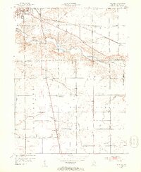
1952 Map of Majenica
USGS Topo · Published 1953About this map
The Wabash River meanders across this Huntington County landscape, defining the northern geography alongside the Erie RR corridor. During the early 1950s, the area surrounding the city of Huntington supported a blend of municipal infrastructure and rural community life, evidenced by the Huntington Waterworks, the County Infirmary, and the Huntington Municipal Airport. The map highlights a network of small centers such as Majenica, Rock Creek Center, and Simpson, while preserving the locations of numerous historic country churches and burial grounds like Loon Creek Ch and Rees Cem. A distinct legal boundary, the Richardville Reserve No 36, appears on the eastern edge, a remnant of earlier land divisions. Drainage and irrigation are meticulously charted through features like Elekenberry Ditch and Ellis Ditch, which supported the agricultural character of the region.
Find a feature on this map
25 named features on this map. Tap any name to fly to it.
Don’t see what you’re looking for? This feature index may not catch every label — zoom into the map to look around manually.
Map Details
Editions of this 1952 Majenica Map
2 editions found
Other maps of this area

1950 · Andrews
USGS Topo · 1:24,000

1950 · Warren
USGS Topo · 1:24,000

1950 · Mount Etna
USGS Topo · 1:24,000

1951 · Mount Etna
USGS Topo · 1:24,000

1951 · Andrews
USGS Topo · 1:24,000

1952 · Warren
USGS Topo · 1:24,000

1952 · Majenica
USGS Topo · 1:24,000

1953 · Muncie
USGS Topo · 1:250,000

1955 · Markle
USGS Topo · 1:24,000

1955 · Bippus
USGS Topo · 1:24,000