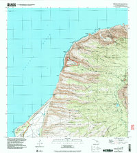
1991 Map of Makaha Point
USGS Topo · Published 2003About this map
Pacific Missile Range Facility installations dominate the western coastal shelf of Kauai in this late twentieth-century survey, juxtaposing high-tech infrastructure against the dramatic, deeply eroded ridges of the Napali Kona Coast. The landscape is defined by an intricate network of narrow valleys and sharp divides, such as Kauhao Ridge and Polihale Ridge, which descend from the high interior toward the sea. Large protected tracts including the Napali Kona Forest Reserve and Ku'ia Natural Area Reserve preserve the upland terrain. Along the southern coast, the Polihale State Park and Kekaha Game Management Area reflect the area's use for recreation and conservation. The map also documents vital water resources in this complex environment, from Pahole Spring to the Halemanu Water Tank, alongside landmarks like the Pu'uhonua Lookout.
Find a feature on this map
80 named features on this map. Tap any name to fly to it.
Don’t see what you’re looking for? This feature index may not catch every label — zoom into the map to look around manually.
Map Details
Editions of this 1991 Makaha Point Map
This is the sole edition of this map. No revisions or reprints were ever made.
Other maps of this area

1954 · Kauai
USGS Topo · 1:250,000

1963 · Kekaha
USGS Topo · 1:24,000

1965 · Waimea Canyon
USGS Topo · 1:24,000

1965 · Haena
USGS Topo · 1:24,000

1965 · Makaha Point
USGS Topo · 1:24,000

1967 · Kauai
USGS Topo · 1:250,000

1970 · Kauai
USGS Topo · 1:250,000
1983 · Haena
USGS Topo · 1:24,000
1983 · Makaha Point
USGS Topo · 1:24,000
1983 · Kekaha
USGS Topo · 1:24,000