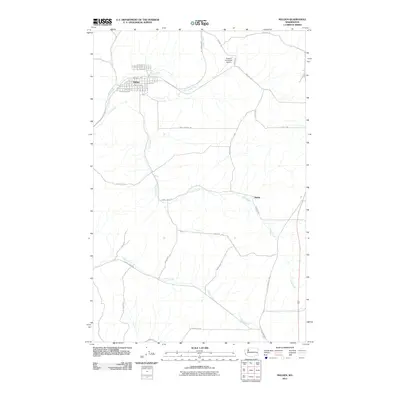
2011 Map of Malden
USGS Topo · Published 2011About this map
Malden and the surrounding agricultural landscape of Whitman County are presented here in the early 21st century, revealing a grid-based townsite defined by streets such as Main St and Railroad Ave. The local infrastructure is shaped by the presence of the Rosalia Municipal Airport and the conversion of former rail corridors into the John Wayne Trl. This transition from active rail to recreational trail reflects the changing economic utility of the Palouse region, while the network of unpaved and rural routes like Old Thornton Hwy and Washboard Rd continues to serve the scattered homesteads and farming operations.
Find a feature on this map
40 named features on this map. Tap any name to fly to it.
Don’t see what you’re looking for? This feature index may not catch every label — zoom into the map to look around manually.
Map Details
Editions of this 2011 Malden Map
This is the sole edition of this map. No revisions or reprints were ever made.
Other maps of this area

1903 · Oakesdale
USGS Topo · 1:125,000

1905 · Oakesdale
USGS Topo · 1:125,000

1954 · Cheney
USGS Topo · 1:62,500

1954 · Spangle
USGS Topo · 1:62,500

1955 · Spokane
USGS Topo · 1:250,000

1958 · Spokane
USGS Topo · 1:250,000

1964 · St. John
USGS Topo · 1:24,000

1964 · Malden
USGS Topo · 1:24,000
1964 · Steptoe
USGS Topo · 1:24,000
1964 · Rosalia
USGS Topo · 1:24,000