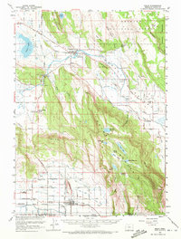
1957 Map of Malin
USGS Topo · Published 1972About this map
The Lost River anchors this mid-century look at the Klamath Basin, winding through agricultural valleys and past the irrigation networks of the Langel Valley and Poe Valley. Settlement is concentrated in the southern town of Malin, where the Malin High Sch and a grid of rural roads reflect a community built on the reclaimed land near the California border. To the north, Bonanza serves as a secondary hub near the Bonanza Memorial Park, situated where the river enters the more rugged volcanic landscape of the Fremont National Forest. High points like Bryant Mountain and Dead Indian Hill dominate the central terrain, separated by a series of man-made reservoirs and natural water features including Alkali Lake and Hot Springs. The map reveals the intricate water management system of the era, from the Lost River Pipeline to the numerous pumps and canals supporting the region's ranching and farming operations.
Find a feature on this map
46 named features on this map. Tap any name to fly to it.
Don’t see what you’re looking for? This feature index may not catch every label — zoom into the map to look around manually.
Map Details
Editions of this 1957 Malin Map
2 editions found

Other maps of this area

1886 · Modoc Lava Bed
USGS Topo · 1:250,000

1889 · Klamath
USGS Topo · 1:250,000

1892 · Modoc Lava-Bed
USGS Topo · 1:250,000

1894 · Klamath
USGS Topo · 1:250,000

1950 · Mt. Dome
USGS Topo · 1:62,500

1951 · Clear Lake Reservoir
USGS Topo · 1:62,500

1951 · Tulelake
USGS Topo · 1:62,500

1954 · Alturas
USGS Topo · 1:250,000

1955 · Klamath Falls
USGS Topo · 1:250,000

1957 · Merrill
USGS Topo · 1:62,500