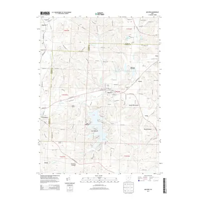
2013 Map of Malvern
USGS Topo · Published 2013About this map
Malvern and its surrounding countryside in Carroll and Stark Counties are defined by the convergence of winding waterways and rural crossroads. The village sits at the junction of Sandy Creek and Armstrong Run, where the Hardesty PO and Saint Xavier Cem mark the established community center. To the south, the sprawling waters of Lake Mohawk dominate the landscape, surrounded by residential developments and wooded terrain like Turkey Hollow. This 2013 survey illustrates the local importance of aviation and regional connectivity, featuring both Furey Airport and Minerva Airport near the northern boundary. Smaller settlements such as Oneida and Minerva Junction are linked by a network of rural roads including Alliance Rd NW and Canton Rd NW. For genealogists and local historians, several family and church burial grounds are documented, from Salem Cem in the north to Woods Cem near Fritchleys Corners.
Find a feature on this map
117 named features on this map. Tap any name to fly to it.
Don’t see what you’re looking for? This feature index may not catch every label — zoom into the map to look around manually.
Map Details
Editions of this 2013 Malvern Map
This is the sole edition of this map. No revisions or reprints were ever made.
Other maps of this area

1901 · Canton
USGS Topo · 1:62,500

1903 · Canton
USGS Topo · 1:62,500

1909 · Alliance
USGS Topo · 1:62,500

1910 · Carrollton
USGS Topo · 1:62,500

1912 · Dover
USGS Topo · 1:62,500

1912 · Carrollton
USGS Topo · 1:62,500

1944 · Dover
USGS Topo · 1:62,500

1951 · Canton
USGS Topo · 1:250,000

1953 · Canton
USGS Topo · 1:250,000

1957 · Canton
USGS Topo · 1:250,000