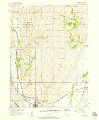
1956 Map of Malvern
USGS Topo · Published 1958About this map
The town of Malvern serves as the focal point of this mid-century survey of Mills County, where the Chicago Burlington and Quincy railroad establishes a critical corridor through the prairie landscape. The terrain is characterized by the winding path of Silver Creek and the Nishnabotna River, which define the agricultural townships of Ingraham and Indian Creek. This map captures a rural social network organized around small local institutions, many of which were central to Iowa farm life before the consolidation of rural school districts.
Find a feature on this map
24 named features on this map. Tap any name to fly to it.
Don’t see what you’re looking for? This feature index may not catch every label — zoom into the map to look around manually.
Map Details
Editions of this 1956 Malvern Map
2 editions found
Other maps of this area

1954 · Omaha
USGS Topo · 1:250,000

1955 · Nebraska City
USGS Topo · 1:250,000

1956 · Glenwood
USGS Topo · 1:24,000

1956 · Mineola
USGS Topo · 1:24,000

1956 · Treynor
USGS Topo · 1:24,000

1956 · Malvern
USGS Topo · 1:24,000

1957 · Nebraska City
USGS Topo · 1:250,000

1957 · Omaha
USGS Topo · 1:250,000

1957 · Tabor
USGS Topo · 1:24,000

1957 · Tabor NE
USGS Topo · 1:24,000