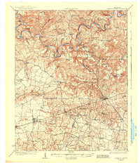
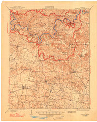
1923 Map of Mammoth Cave
USGS Topo · Published 1937About this map
The Green River carves a deep, winding path through this karst landscape, serving as the primary geographic anchor for the region's early 20th-century development. Before the establishment of modern infrastructure, river travel remained vital, evidenced by numerous crossings like Fishtrap Ferry, Dennison Ferry, and Houchins Ferry. These water-based transit points connected isolated ridges and settlements such as Cade and Arthur to the broader commercial networks. The map documents the early years of Mammoth Cave National Park, highlighting subterranean landmarks like Great Onyx Cave, Crystal Cave, and the New Entrance Mammoth Cave. To the south, the Louisville And Nashville RR corridors define a different economic reality, supporting established towns like Smiths Grove and Glasgow Junction. The distribution of numerous rural schools, such as Little Hope School and Stony Point School, reflects the decentralized, church-centered communities of the era, many of which were located near sinks and springs.
Find a feature on this map
107 named features on this map. Tap any name to fly to it.
Don’t see what you’re looking for? This feature index may not catch every label — zoom into the map to look around manually.
Map Details
Editions of this 1923 Mammoth Cave Map
6 editions found
Other maps of this area

1921 · Bowling Green
USGS Topo · 1:62,500

1922 · Leitchfield
USGS Topo · 1:48,000

1922 · Brownsville
USGS Topo · 1:62,500

1922 · Mammoth Cave
USGS Topo · 1:62,500

1923 · Bowling Green
USGS Topo · 1:62,500

1923 · Mammoth Cave
USGS Topo · 1:62,500

1923 · Brownsville
USGS Topo · 1:62,500

1925 · Cub Run
USGS Topo · 1:62,500

1925 · Leitchfield
USGS Topo · 1:62,500

1926 · Scottsville
USGS Topo · 1:62,500