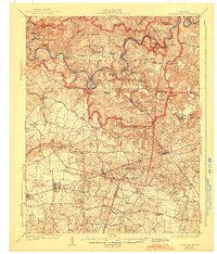
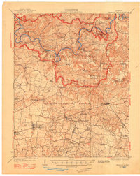
1923 Map of Mammoth Cave
USGS Topo · Published 1944About this map
The Green River and its intricate drainage system define this Kentucky landscape, captured here after a 1921-1922 survey. The map details a period when the river was a primary artery of movement, evidenced by numerous river crossings such as Webb Ferry, Houchins Ferry, and the Sanders Ferry at Turnhole Bend. The region's unique subterranean geography is prominently marked within the Mammoth Cave National Park boundary, including famous landmarks like Colossal Cave and Great Onyx Cave.
Find a feature on this map
102 named features on this map. Tap any name to fly to it.
Don’t see what you’re looking for? This feature index may not catch every label — zoom into the map to look around manually.
Map Details
Editions of this 1923 Mammoth Cave Map
6 editions found
Other maps of this area

1921 · Bowling Green
USGS Topo · 1:62,500

1922 · Leitchfield
USGS Topo · 1:48,000

1922 · Brownsville
USGS Topo · 1:62,500

1922 · Mammoth Cave
USGS Topo · 1:62,500

1923 · Bowling Green
USGS Topo · 1:62,500

1923 · Mammoth Cave
USGS Topo · 1:62,500

1923 · Brownsville
USGS Topo · 1:62,500

1925 · Cub Run
USGS Topo · 1:62,500

1925 · Leitchfield
USGS Topo · 1:62,500

1926 · Scottsville
USGS Topo · 1:62,500