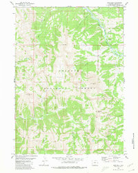
1980 Map of Man Peak
USGS Topo · Published 1980About this map
Bridger National Forest dominates this section of Lincoln County, where the topography rises sharply toward the summit of Man Peak. The area is defined by a dense network of high-altitude drainages, including Greys River and its various tributaries like Moose Creek and Little Elk Creek. The presence of several Pack Trail routes suggests a landscape primarily accessible by foot or horse, connecting remote peaks such as Haystack Peak and Virginia Peak. A modest node of human activity is visible at Moose Flat Campground, situated near the confluence of Moose Creek and Greys River. The mapping of features like Indian Grave Flat and Dry Canyon provides specific reference points for those studying the land use and natural landmarks of the northern Wyoming ranges during the late twentieth century.
Find a feature on this map
23 named features on this map. Tap any name to fly to it.
Don’t see what you’re looking for? This feature index may not catch every label — zoom into the map to look around manually.
Map Details
Editions of this 1980 Man Peak Map
2 editions found
Other maps of this area

1921 · Afton
USGS Topo · 1:125,000

1931 · Jackson
USGS Topo · 1:125,000

1935 · Jackson
USGS Topo · 1:125,000

1955 · Driggs
USGS Topo · 1:250,000

1955 · Preston
USGS Topo · 1:250,000

1958 · Driggs
USGS Topo · 1:250,000

1958 · Preston
USGS Topo · 1:250,000

1962 · Driggs
USGS Topo · 1:250,000

1962 · Preston
USGS Topo · 1:250,000

1965 · Pickle Pass
USGS Topo · 1:24,000