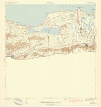
1942 Map of Manati
USGS Topo · Published 1942About this map
Laguna Tortuguero dominates the central coastline between the municipalities of Manati and Vega Baja in this 1940 survey. The landscape is a transition from the Atlantic Ocean shoreline at Pta Tortuguero to the fertile agricultural plains and limestone mogotes to the south. The settlement pattern is characterized by several colonias and desvios, reflecting the regional sugar industry’s influence on the local economy and transport network.
Find a feature on this map
37 named features on this map. Tap any name to fly to it.
Don’t see what you’re looking for? This feature index may not catch every label — zoom into the map to look around manually.
Map Details
Editions of this 1942 Manati Map
2 editions found
Other maps of this area

1940 · Vega Alta
USGS Topo · 1:30,000

1942 · Manati
USGS Topo · 1:30,000

1942 · Barceloneta
USGS Topo · 1:30,000

1946 · Corozal
USGS Topo · 1:30,000

1946 · Barceloneta
USGS Topo · 1:30,000

1946 · Ciales
USGS Topo · 1:30,000

1946 · Florida
USGS Topo · 1:30,000

1946 · Vega Alta
USGS Topo · 1:30,000

1946 · Manati
USGS Topo · 1:30,000

1947 · Corozal NO
USGS Topo · 1:10,000