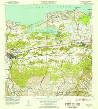
1953 Map of Manati
USGS Topo · Published 1954About this map
The coastal plains and limestone hills of northern Puerto Rico define this mid-century landscape centered on the municipality of Manati. Agricultural activity is prominent throughout the lowlands, evidenced by numerous named agricultural settlements such as Colonia Felix Cordova Davila and Colonia Coto Norte. The American RR serves as a primary transit artery, winding through the terrain with specialized rail sidings including Desvio Cantera and Desvio Campo Alegre. Along the shoreline, the significant Laguna Tortuguero sits within a Reservacion Militar, which also contains Camp Tortuguero and the Vega Baja Airstrip. Further inland, the terrain transitions to the mogotes and valleys of Pugnado Adentro and Almirante Sur, where localized social centers like the Iglesia Santos Apostoles and Escuela Quebrada Arenas served rural families. The confluence of the Rio Cibuco and the Atlantic at Boca del Cibuco anchors the eastern edge of the survey.
Find a feature on this map
81 named features on this map. Tap any name to fly to it.
Don’t see what you’re looking for? This feature index may not catch every label — zoom into the map to look around manually.
Map Details
Editions of this 1953 Manati Map
2 editions found
Other maps of this area

1940 · Vega Alta
USGS Topo · 1:30,000

1942 · Manati
USGS Topo · 1:30,000

1942 · Barceloneta
USGS Topo · 1:30,000

1946 · Corozal
USGS Topo · 1:30,000

1946 · Barceloneta
USGS Topo · 1:30,000

1946 · Ciales
USGS Topo · 1:30,000

1946 · Florida
USGS Topo · 1:30,000

1946 · Vega Alta
USGS Topo · 1:30,000

1946 · Manati
USGS Topo · 1:30,000

1947 · Corozal NO
USGS Topo · 1:10,000