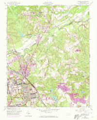
1957 Map of Manchester
USGS Topo · Published 1973About this map
The Fort Bragg Military Reservation dominates this mid-century landscape, illustrating the massive expansion of military infrastructure alongside the Little River. The map captures a critical period of growth for Spring Lake, which serves as a primary residential and commercial hub adjacent to the base. The presence of Pope Air Force Base and the Seaboard Coast Line railroad highlights the strategic transportation and defense networks that shaped Cumberland County.
Find a feature on this map
34 named features on this map. Tap any name to fly to it.
Don’t see what you’re looking for? This feature index may not catch every label — zoom into the map to look around manually.
Map Details
Editions of this 1957 Manchester Map
4 editions found
Other maps of this area

1948 · Fayetteville
USGS Topo · 1:62,500

1948 · Clifdale
USGS Topo · 1:62,500

1948 · Slocomb
USGS Topo · 1:24,000

1948 · Clifdale
USGS Topo · 1:24,000

1949 · Vander
USGS Topo · 1:24,000

1950 · Clifdale
USGS Topo · 1:24,000

1950 · Fayetteville
USGS Topo · 1:24,000

1950 · Manchester
USGS Topo · 1:24,000

1950 · Slocomb
USGS Topo · 1:24,000

1951 · Clifdale
USGS Topo · 1:62,500