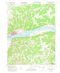
1961 Map of Manchester Islands
USGS Topo · Published 1975About this map
Manchester sits prominently along the northern bank of the Ohio River, serving as a focal point for this borderland geography. The landscape transitions from the river valley into the dissected uplands of Chalk Ridge and the heights of Hymes Knob and Big Brier Knob. Significant river features like Manchester Island No 1 and Manchester Island No 2 split the channel, while the Chesapeake and Ohio railroad corridor tracks the southern shoreline in Kentucky.
Find a feature on this map
51 named features on this map. Tap any name to fly to it.
Don’t see what you’re looking for? This feature index may not catch every label — zoom into the map to look around manually.
Map Details
Editions of this 1961 Manchester Islands Map
4 editions found
Other maps of this area

1916 · Peebles
USGS Topo · 1:62,500

1918 · Peebles
USGS Topo · 1:62,500

1918 · Seaman
USGS Topo · 1:62,500

1919 · Vanceburg
USGS Topo · 1:62,500

1929 · Springdale
USGS Topo · 1:48,000

1935 · Springdale
USGS Topo · 1:62,500

1949 · Vanceburg
USGS Topo · 1:62,500

1949 · Concord
USGS Topo · 1:24,000

1949 · Charters
USGS Topo · 1:24,000

1950 · Charters
USGS Topo · 1:24,000