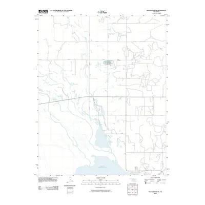
2009 Map of Manchester SW
USGS Topo · Published 2009About this map
Great Salt Plains Reservoir dominates the southern landscape of this 2009 Alfalfa County survey, where the Salt Fork Arkansas River feeds into the northern reaches of the wildlife-rich basin. The terrain is defined by a grid of rural roads and the hydrological network of Sandy Creek and Powell Creek, which meander southward toward the lake. This edition reveals a specialized local economy and land use pattern through the presence of the Byron State Fish Hatchery, located near the intersection of several municipal roads. Genealogists and local historians can locate the Ware Cemetery in the northeastern quadrant, a key landmark for tracing family roots in this agricultural region. Smaller water bodies like Upper Dog Pond and Dog Pond further punctuate the landscape between the hatchery and the main reservoir.
Find a feature on this map
21 named features on this map. Tap any name to fly to it.
Don’t see what you’re looking for? This feature index may not catch every label — zoom into the map to look around manually.
Map Details
Editions of this 2009 Manchester SW Map
This is the sole edition of this map. No revisions or reprints were ever made.
Other maps of this area

1955 · Woodward
USGS Topo · 1:250,000

1958 · Woodward
USGS Topo · 1:250,000

1969 · Jet
USGS Topo · 1:24,000

1969 · Amorita
USGS Topo · 1:24,000
1969 · Manchester
USGS Topo · 1:24,000

1969 · Nash
USGS Topo · 1:24,000
1969 · Sand Creek
USGS Topo · 1:24,000

1969 · Manchester SW
USGS Topo · 1:24,000
1969 · Manchester NW
USGS Topo · 1:24,000

1969 · Cherokee North
USGS Topo · 1:24,000