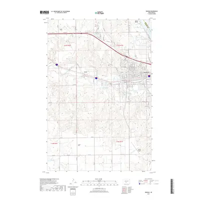
2017 Map of Mandan
USGS Topo · Published 2017About this map
The confluence of the Missouri River and the Heart River defines the landscape of this 2017 survey, where the urban grid of Mandan meets the high ground of the Missouri plateau. The city occupies the northeastern portion of the sheet, bounded by the river’s winding course and the rising terrain of Custer Flats. The map details a modern transportation network, from the residential streets surrounding Sunset Park to the Mandan Municipal Airport in the south and the private Landeis Airstrip to the west. Local history is anchored by Saint Josephs Cem and the settlement of Rock Haven along the northern riverbank. Significant topographic features like Dead Heart Slough indicate the complex drainage patterns of the river valley, while the presence of the Old Red Trl recalls the region's early vehicular transit routes through Morton County.
Find a feature on this map
113 named features on this map. Tap any name to fly to it.
Don’t see what you’re looking for? This feature index may not catch every label — zoom into the map to look around manually.
Map Details
Editions of this 2017 Mandan Map
This is the sole edition of this map. No revisions or reprints were ever made.
Other maps of this area

1907 · Bismarck
USGS Topo · 1:125,000

1950 · Bismarck
USGS Topo · 1:24,000

1951 · Bismarck
USGS Topo · 1:62,500

1951 · Mandan
USGS Topo · 1:24,000

1954 · Bismarck
USGS Topo · 1:250,000

1958 · Bismarck
USGS Topo · 1:250,000

1962 · Schmidt
USGS Topo · 1:24,000

1962 · Bismarck
USGS Topo · 1:24,000

1962 · Harmon
USGS Topo · 1:24,000
1962 · Burnt Butte
USGS Topo · 1:24,000