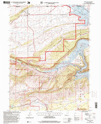
1996 Map of Manila
USGS Topo · Published 1999About this map
The town of Manila serves as the gateway to a dramatic landscape defined by the impounded waters of the Green River and the canyon walls of Flaming Gorge. This survey, updated in the late 1990s, documents the interface between the agricultural valley floors of Lucerne Valley and South Valley and the steep terrain of the Ashley National Forest. Along the western shore of Flaming Gorge Reservoir, the map identifies localized recreational infrastructure including the Sheep Creek Boat Ramp and remote sites like Kingfisher Boat Camp on the river's edge. Further south, the high country is marked by Windy Ridge and Dowd Mountain, featuring ecological exclosures like the Death Valley Exclosure. The presence of the Summit Springs Guard Station and the Ranger District Headquarters underscores the area's administration as a public recreation and forest resource.
Find a feature on this map
43 named features on this map. Tap any name to fly to it.
Don’t see what you’re looking for? This feature index may not catch every label — zoom into the map to look around manually.
Map Details
Editions of this 1996 Manila Map
This is the sole edition of this map. No revisions or reprints were ever made.
Other maps of this area

1885 · Ashley
USGS Topo · 1:250,000

1906 · Marsh Peak
USGS Topo · 1:125,000

1908 · Marsh Peak
USGS Topo · 1:125,000

1952 · Flaming Gorge
USGS Topo · 1:24,000

1954 · Vernal
USGS Topo · 1:250,000

1954 · Rock Springs
USGS Topo · 1:250,000

1958 · Vernal
USGS Topo · 1:250,000

1958 · Rock Springs
USGS Topo · 1:250,000

1960 · Vernal
USGS Topo · 1:250,000

1962 · Rock Springs
USGS Topo · 1:250,000