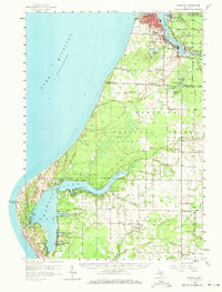
1958 Map of Manistee
USGS Topo · Published 1971About this map
Manistee Lake and the busy shoreline of Lake Michigan define this mid-century portrait of coastal industry and recreation. At the mouth of the Manistee River, the settlements of Manistee and East Lake anchor a region shaped by salt production and timber legacies, evidenced by numerous Salt Wells and the Shingle Mill Lake to the south. The Chesapeake and Ohio railroad threads through Filer City and Stronach, connecting the lakefront hubs to the interior. Further south, the expansive waters of Hamlin Lake and the reaches of Ludington State Park near Big Sable Point show a landscape transitioning from resource extraction to protected natural space. Genealogists will find significant local detail in the many rural landmarks, including the Old Indian Cem, several country schools like Ayres Sch, and churches such as Sacred Heart Ch and Trinity Ch.
Find a feature on this map
82 named features on this map. Tap any name to fly to it.
Don’t see what you’re looking for? This feature index may not catch every label — zoom into the map to look around manually.
Map Details
Editions of this 1958 Manistee Map
3 editions found

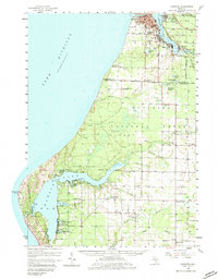
Other maps of this area

1931 · Custer NW
USGS Topo · 1:31,680

1931 · Manistee SE
USGS Topo · 1:31,680

1931 · Freesoil SW
USGS Topo · 1:31,680

1931 · Manistee SW
USGS Topo · 1:31,680

1932 · Ludington NE
USGS Topo · 1:31,680

1932 · Ludington
USGS Topo · 1:31,680

1954 · Milwaukee
USGS Topo · 1:250,000

1954 · Manitowoc
USGS Topo · 1:250,000

1956 · Onekama
USGS Topo · 1:62,500

1956 · Bar Lake
USGS Topo · 1:62,500