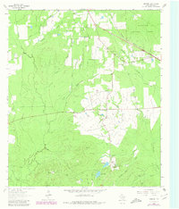
1963 Map of Manning
USGS Topo · Published 1980About this map
Manning and Shawnee Prairie stand as central points of interest in this survey of southeastern Angelina County. The landscape is defined by the heavy timber of the Angelina National Forest and an intricate drainage system including Buck Creek, Caney Creek, and Shawnee Creek. Traces of the region's industrial past are preserved through the identification of an Old RR Grade and Old Railroad Grade that once served the lumber industry, alongside the active Southern Pacific line. Genealogists will find significant value in the distribution of family-named landmarks and rural burial grounds, such as Treadwell Cem, Carrell Cem, and Renfro Cem. Religious life in these rural communities is anchored by Salem Ch and James Chapel, while local topography is noted by elevations like Lala Hill and Bill Hill.
Find a feature on this map
29 named features on this map. Tap any name to fly to it.
Don’t see what you’re looking for? This feature index may not catch every label — zoom into the map to look around manually.
Map Details
Editions of this 1963 Manning Map
Other maps of this area

1927 · Lufkin 4-c
USGS Topo · 1:24,000

1928 · Zavalla 3-c
USGS Topo · 1:24,000

1928 · Lufkin 4-d
USGS Topo · 1:24,000

1931 · Zavalla
USGS Topo · 1:62,500

1932 · Manning
USGS Topo · 1:62,500

1949 · Lufkin
USGS Topo · 1:62,500

1949 · Lufkin
USGS Topo · 1:24,000

1949 · Huntington
USGS Topo · 1:24,000

1950 · Lufkin
USGS Topo · 1:24,000

1950 · Huntington
USGS Topo · 1:24,000