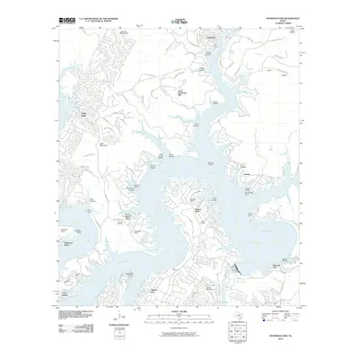
2010 Map of Mansfield Dam
USGS Topo · Published 2010About this map
Mansfield Dam and the larger Marshall Ford Dam anchor this transition point between Lake Travis and Lake Austin, documenting a landscape defined by the winding course of the Colorado River. The 2010 shoreline is complex, with numerous geographic points like Windy Point, Graveyard Point, and Point Venture extending into the water. Settlement patterns here are distinctly lakeside, from established communities like Jonestown and Lago Vista to smaller developments such as North Shore Acres and Edgewater Beach. Genealogy and local history are reflected in family-named landmarks and resting places, including Simpson Cemetery near Arkansas Bend and Teck Cemetery further south. The map also captures specialized infrastructure like the Lago Vista Bar-K Airpark and the rugged local terrain of Buckskin Ridge and Bald Mountain, showing the intersection of recreation and geography in the Texas Hill Country.
Find a feature on this map
59 named features on this map. Tap any name to fly to it.
Don’t see what you’re looking for? This feature index may not catch every label — zoom into the map to look around manually.
Map Details
Editions of this 2010 Mansfield Dam Map
This is the sole edition of this map. No revisions or reprints were ever made.
Other maps of this area

1887 · Blanco
USGS Topo · 1:125,000

1887 · Burnet
USGS Topo · 1:125,000

1893 · Georgetown
USGS Topo · 1:125,000

1893 · Burnet
USGS Topo · 1:125,000

1894 · Blanco
USGS Topo · 1:125,000

1896 · Austin
USGS Topo · 1:125,000

1897 · Austin
USGS Topo · 1:125,000

1903 · Burnet
USGS Topo · 1:125,000

1909 · Burnet
USGS Topo · 1:125,000

1910 · Austin
USGS Topo · 1:125,000